What to See at Pictured Rocks
A highlights guide to Michigan's Lake Superior shoreline park.
Pictured Rocks is one of those places that genuinely looks like the postcards: 15 miles of mineral-streaked sandstone cliffs dropping straight into Lake Superior, with waterfalls, a 300-foot dune, and a 19th-century lighthouse thrown in. The catch: the most famous cliffs face the water, so seeing them well means a boat or a kayak. Here's what's worth your time and how to actually reach each piece.
The cliffs (and the only real way to see them)
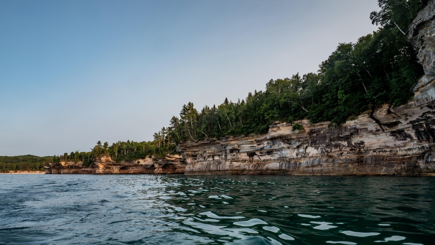
The painted cliffs are the reason the park exists. Iron, copper, and manganese leaching out of the rock stain the sandstone red, orange, and green (hence "Pictured Rocks"). The formations have names like Miners Castle, Battleship Row, and Lovers Leap, where a rock arch frames the water.
From land you only get glimpses. To see the full wall, you have two real options:
- Pictured Rocks Cruises boat tour out of Munising, the easy, kid-friendly choice. A few hours, narrated, no effort required. It's the single best way to take in the whole stretch.
- Sea kayaking along the cliffs, far more dramatic, paddling right under Lovers Leap and into the colored coves. Lake Superior is cold and moody, so go with one of the authorized guide companies unless you genuinely know what you're doing.
Miners Castle and Miners Falls
If you only have a couple hours on the east-Munising side, this is the duo to hit. Miners Castle is the one cliff formation you can see properly from shore, a turreted sandstone point with paved overlooks a short walk from the parking lot. It's the most accessible big view in the park.
Nearby, Miners Falls is a short forest hike to a genuinely powerful waterfall, water pouring over a sandstone ledge. The trail has stairs near the end, but it's manageable for most families.
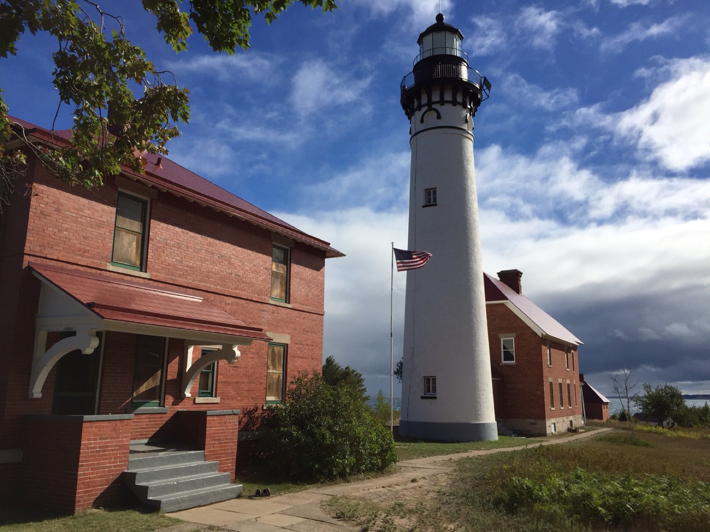
The Grand Sable Dunes and Au Sable Light Station
The east end of the park, near Grand Marais, has a completely different character. The Grand Sable Dunes rise about 300 feet straight up from Lake Superior, perched dunes you can climb for a sweeping shoreline view. The Au Sable Light Station, a working-era lighthouse with keeper's quarters, sits along the same stretch of coast and makes a good walk-to destination.
Note the geography: Pictured Rocks is long and thin, stretched between Munising on the west and Grand Marais on the east. County Road H-58 connects the two, but it's not a quick hop. Don't expect to do the cliffs and the dunes casually in the same afternoon.
Hikes worth the boots
The signature walk is the Chapel / Mosquito loop, a clifftop trail past collapsed arches, beaches, and the best on-foot views of the painted rock. It's a real hike, not a stroll, but it's the one to plan around if your group can handle the miles.
For shorter legs and younger kids:
- Sand Point Marsh Trail, a flat, accessible boardwalk near the Munising visitor center, easy and good for wildlife.
- Sand Point Beach, the most family-friendly swimming spot, calmer and warmer than most of the open Superior shoreline (and that's relative. This is still Lake Superior).
- The park's own "places to see in one hour" and "walks of a mile or less" cover the quick stops if you're short on time.
Beaver Basin Wilderness and the quiet corners
Between the headline sights, the Beaver Basin Wilderness holds inland lakes, quiet creeks, and backcountry campsites for people who want the park without the crowds. You can canoe on Little Beaver Lake or backpack the shoreline. It's the answer to "is there anything past the boat tour?" Yes, and it's where the park gets peaceful.
Practical notes: there's a $25 per-vehicle entrance fee good for seven days. Summer highs sit in the 70s, which is the window most people want. And the Upper Peninsula commits to winter: roughly 140 inches of snow a year closes most park roads from late fall into spring, so plan accordingly.
Planning the trip? Nestward builds a day-by-day plan in minutes, free, no subscription. See how it works →